Posted by: Pete | June 12, 2010

NUT HAS MOVED!!! (this is my last post here)

This blog is (was) hosted on the Free wordpress.com server.  Although it is a great free service, there comes a time when you want to do something, and the free service won’t let you.

So I have moved to:

nakedkiwi.co.nz

yeah.

Don’t ask 🙂  It’s historic.  Anyway, make your way over to nakedkiwi.co.nz if you want to see what happened since the 11th of June 2010!

See you there. Update any bookmarks, links or blogrolls please.

Posted by: Pete | June 9, 2010

Winter Solstice

Picking up tramping as a hobby lifestyle means you also become much more intimate with other things of life that you can ignore under, what used to be, normal circumstances.

Things such as weather forecasting, seasonal weather patterns and the numbers of hours of daylight in a given day.

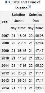
Winter Solstice Dates and Times -- Wikipedia

It’s the latter interest that caused me to note that the Winter Solstice, the day with the shortest day and longest night, isn’t too far away already. The Winter Solstice for the Southern Hemisphere in 2010 is on the 21st this month, at 11:28 UTC.

In other words, on the 21st of June 2010, 23:28 NZST, as in New Zealand we are UTC + 12 while daylight savings isn’t ‘on’.

That doesn’t mean it is the middle of winter, mind you. It generally marks the start of the 6 or 8 coldest weeks however. After those, the amount of tilt towards the sun changes sufficiently for days to become longer, and more warmth is enjoyed from our lovely sun.

Near the top of the south of the South Island, the sun currently only stays with us from about 8 am until 5 pm. Allowing for dawn and dusk on a clear day, that gives you about 10 hours of usable Tramping Light.

During the summer you might entertain walking into a hut for 5 hours, have a break, and walk back out, for an 11 or 12 hour trip. But doing so now means walking in the dark or considering an overnighter.

So, our general range is shortly going to be the least it will be for the year, and after few cold weeks, we can start looking forward to longer and, eventually, warmer days again.

Yeah!

2010 21 11:28

Posted by: Pete | June 8, 2010

Trip: 20100607 Hacket

Cabin Fever.

It’s horrible. Especially when Mrs nut manages to sprain her ankle and Mr turns into a domestic servant for wife and children for 3 days.

Trip photos @ Panoramio

So getting out for a few hours turned into a mental health issue.

The rain hadn’t gone for long – 6 hours at the most.

The plan? To zap up a forestry track to a summit, place a cache, bush bash to the top of Whispering Falls, drop down, hop over the bridge, do an Earth Cache, go up to the Chromite Mine and ping a cache there too.

What really happened:

Forestry road has a big ugly sign saying it’s private and access by permit only. Now, Mr nut may do the odd bit of civil disobedience, but he can’t send people up there on purpose to find a cache. Hmmm… time for Plan B.

Plan B was to go to the Chromite mine and do the cache.

Left the coords to the Chromite mine in the car. Darnit. Never mind.

Plan C was to go to the Chromite mine anyway, look around for an obvious hiding spot, and whatever happens, walk on to the summit and place a cache.

Swollen Creek on the way to Chromite Mine

After a brief walk up the track to the mine, I was stopped by a swollen creek. I could have crossed it, but I didn’t want to get soaked. The water was coming down at a fair clip, and I would have been wet up to my waist. With a few hours of walking ahead of me, I decided to turn back.

Plan C was to do the nearby Earth Cache. Yes, I had left the instructions in the car, but I also had them in my phone as part of my paperless caching information. As it turns out, I passed both signs you need to take note of on the way up to the swollen stream and already had taken their pictures. All I had to do now is walk to the other end of the Nelson Mineral Belt, and take a waypoint.

I left the track to the mine, and set off on the track to the spot where I had to take the waypoint. I met the same creek in a different place.

Plan D was to go visit the nearby Whispering Falls. They’re called Whispering because normally they are just a little more than a damp wall of moss with some water dripping down. After the rain, I was hoping it would be in full flight and, if not yelling, at least talking normally.

I got to the bridge over the Miner River when I noticed that there was a bit of an animal trail that continued on. “Hmmmm”, I thought, “let’s see where that leads”.

Plan E was a bit of a bush bash down the Miner River. The animal track, such as it was, faded in and out, but I managed to pick it up time after time. At one stage it got a little nasty and a solid bit of bush looked like hard work.

I looked up the hill side. “Hmmmm”, I thought, “a rocky outcrop”, and started up.

No trail at all, and the ground invisible due to the growth of pig fern, flax, gorse and some woody stunted Pittosporum, I slowly made my way up until I got to the first rocky outcrop. “Hmmmm”, I thought, “that’s not a good place for a cache”, and noticed a larger outcrop further up.

I made it to about 80 m above the river, and hit some gorse. Gorblimey. Sidling around the rock between the gorse and rock face, I managed to get to the other side where there was a gap in between the rock and the next one large enough to stand comfortably.

Cache in the Hacket

After a bit of gardening and rock collecting, I made a spot for the cache to sit. Time for a bite and a drink, and thinking about how to get down.

I started back down towards the river. “Hmmmm”, I thought, “it was much easier going up!”. In almost double the time to get up, I managed to get back down and pick up the trail again. Back to plan D.

The Falls were still only Whispering, but the place is magic. 2nd time here, so I could have a better look. Looks like the sea floor got pushed right up. The waterfall is essentially on top of what looks like a coral reef! The sand that erodes from the hill side is essentially fragments of coral and shells. Amazing.

Well, out of time for a plan F, so after filling the drink bottle with some Whispering Dew, I headed back home.

Although the Cabin Fever was abated to a level where I would not be a danger to myself or others, the last 3 days have left me like a caged tiger. Hopefully in 3 or 4 days I’ll be able to unleash it and clock up the next adventure.

Posted by: Pete | June 6, 2010

Trip cancelled

I know how important it is in life
not necessarily to be strong,
but to feel strong

To measure yourself
at least once

To find yourself at least once
in the most ancient of human conditions

Facing the blind death stone alone
with nothing to help you
but your hands and your own head

Posted by: Pete | June 2, 2010

Trip: 20100515 Red Hills & Beebys

Two ridges with a cache each, 5 km apart, and no track in between.  What to do?  How about my first real bush bash?

Brand new as of April 2010

A cache was published at the new Red Hills Hut, and the FTF was drawing me in.  But the problem was that one ridge over, the Beebys Ridge, also had a cache I had still to find.

Some study of the topo map and Google Earth suggested that there was a route between them that could be attempted.  A quick check with the Tramping Guru and I had my go-ahead.

The recurring theme?  The Metservice forecast.  It said: don’t go.  It’ll be hosing down, strong winds.  Mr nutinahut had a good look at the data, and decided it would be overcast with virtually no wind, with the odd drizzle.

Mr nutinahut wins.  Again.

Honestly, it pays to observe the forecast and what really happens for extended periods so you get to make your own depending on the raw data available.

But I am repeating myself.

At the last minute, Tramping Guru, who was also the cache placer on both ridges, invited himself along.

A gentle walk through the first km of mature Beech (Nothofagus) forest was beautiful, but it wasn’t long before we hit the old 4WD road.  Luckily it’s well established and enclosed by trees and shrubs, and due to the 4WD grade a pleasant walk up.

The only down side was the large group of Garin College students that were returning from a 3 or 4 day hike around the Red Hills.  All credit to the school for taking students on outdoor pursuit adventures.  But what Tramping Guru and I found heartbreaking was the blatant and regular fresh snacking litter we found lying on the track.

Tramping Guru made a point of stopping a few of the leaders as they came down and mentioning this.  The reaction we received wasn’t great.  We could but hope it came up during the post-tramp debrief, and they learn that the only thing they are supposed to leave are… footprints.

A while later, you can see where the road meets the saddle, and it’s not too far to go.  In fact, 2 hours after starting out I was surprised by the hut: it really is just at the end of the road.

We checked the brand new hut out, and it all looked rather shiny.  We quickly spread out, as you do, filling the space for six with just two people.

As our gear was enjoying the fresh air, and our bags were lofting, we decided to go find that cache around the corner – an FTF was to be had!  And, as it turns out, a nice view of the Wairau and Rainbow valleys.

Lake Mixed Veg - none of it was wasted

Apart from “Lake Mixed Veg” caused by Tramping Guru losing control of his pot of hydrating veges, the night was uneventful and we woke to a grey but quiet day.  Would we do the bush bash to the other ridge?

I decided to leave the decision to Tramping Guru, taking his lead as to what he thought of the conditions.  I wasn’t keen to do it by myself, but if he was OK to go, then I’d be keen.

He wanted to go for a valley walk to the next hut.  That didn’t appeal, so I decided to bail out and go home.

This changed Tramping Gurus perspective, and he said “or do you want to do the bush bash to Beebys?”.  Yes, I did.  And so, we packed up and set off on my cross country adventure.

I had prepped this to the hilt, and my GPS had all the waypoints to hit in it.  We started off on a disused 4WD track that was easy to follow albeit getting a little overgrown in places.  We made it to the first ridge a mere 80 m above the hut, and it was already time to change some layers.

Here Tramping Guru and I went in different directions.  He, where he wanted to go, I, where I had planned my route.  We had to do some shouting to find each other again.  A meeting was called.  Once he was clued in that I was going to do it my way, and not his way, he kindly adopted my plan and let me lead the way.  (In hindsight he probably set off on the easier path, but he very smartly let me do my own thing, trusting that we’d cut across his intended route very soon anyway.  But it made me feel very good to have the illusion that I was in control!).

Picking your way through some virgin forest is pretty cool.  The route is the obvious one to take, and at times we came across obvious sign that others had been there before us.  The last ridge climb was pretty much on an old track in fact.  But most of it up to that point had to be bashed through: picking your own path through native forest.  AWESOME.

Tramping Guru let me lead the way for most of it, although I keenly observed him picking his way through easier terrain.  With his experience he knows what side of a ridge the more open forest is likely to be, whereas I was just going to straight line it to the next waypoint.

At one stage we were getting near the top of another ridge and the trees were getting so small, you couldn’t actually walk under them any longer.  That was getting a bit tough.  At the top, the landscape was surreal – the Beech trees were severely stunted and moss everywhere.  It was a place to put a cache, but I had stubbornly refused to bring any containers.  Tramping Guru was better prepared, so he placed one instead.  People who come to do this cache, named “T5”, will have a wonderful adventure.

When we got to Beebys ridge, Tramping Guru and I parted, so he could go and get the car from the Red Hills route car park (he had dropped a bike at the bottom of Beebys) while I took a (slower) side-trip to his cache lower down on the ridge.

We met up again at the bottom, where I gratefully accepted a ride back to my car, cutting out a 7 km road side walk.

A very successful end to the trip with an FTF, my first off-track bush bash and another hut for the bagging list.  And thanks to Tramping Guru for his skills and patience in guiding a novice without making him feel it is happening at the time!

2 found, 1 FTF, 0 DNFs

Trip photos @ Panoramio

Posted by: Pete | June 2, 2010

Trip: 20100523 Rawhiti Cave

It isn’t nice to criticise Metservice repeatedly, but it must be noted that the “Sunny weather with occasional drizzle towards the end of the day” turned into “persistent drizzle turning to steady rain” between 8 and 11 am.  How can they get that so wrong?

Trip photos @ Panoramio

Today’s objective is Rawhiti Cave.  What better place to go to when it is raining?  Except you have to get there first.  Following the instructions I quickly found myself at the first farm gate, with a suitable sign warning that what followed wouldn’t be suitable for town cars in wet weather.  Oh well.  At least I knew they’d have a tractor handy to pull me out!

After a careful drive down the race, and only once muddy patch that momentum took care of, I negotiated the last fence.  Yet another sign forewarned the potential bogginess of the parking area, but things seemed solid to me, and so they proved to be.

Changing to tramping gear in the rain I got my morning shower.  The sign said 1 hour to the Cave, so I decided to hydrate before setting off, and to hand carry a bit of water on the way in.  The Dry River proved dry, and no flash floods looked imminent, so the crossing was uneventful.

After this you follow the river up what can only be described as a baby ravine.  The sheer rock wall on the true right is impressive.  The opposite side less so, but is steep all the same.

Before you know it, you’re at the point where you leave the river, and the steep walk up the zig zags starts in earnest.  At this stage I had drained all the water, and left to bottle to pick up on the way back.  Hands free, nothing on the back, this would prove handy in the slippery conditions.

Seconds later I was confronted by a kid on the track.  A baby goat kind of kid.  It had a good look at me.  Decided to go, and then had curiosity take hold and turned back for another look.  It was only when the big strange looking thing started talking to it that it freaked out and bolted into the greenery.

Apart from a little slipping and sliding, the way up wasn’t too bad.  There are some amazing mature Totara (Podocarpus totara) on the way up, and the occasional Nikau (Rhopalostylis sapida) to remind you that you’re at the temperate end of the Top of the South.

And just as you start to wonder if you’re making any progress towards the cave, you find yourself there.  The obligatory DOC sign with the obligatory warning and a relatively fresh slip that has thrown mud, stones and plant debris across the cave entrance.

Some people have already been through, and a path has formed, so it was easy to negotiate.  And then you look up.

And you’re there.

Unbelievable stalagmites ring the cave entrance like teeth on a monster’s mouth.

I was keen to enter, and so started the 2 hour exploration.  An early loss of footing reminded me to have some respect for my situation, and the 3 points of contact rule was instigated immediately.  Funny thing about caves, some of the most slippery looking things provide good grip, while a little accumulated mud can send you down the monster’s throat.

I was a little gutted that there was no obviously safe way down to the cave floor.  The “Guide ropes” put out by DOC that they wish you stay in between to limit the damage to the cave do not take you all the way.

A few steps off the suggested track here and there to get a better look at some features aside, to go all the way probably needs a rope and some companions for safety.  I was painfully aware my PLB was no good inside a cave, and any problems meant I was stuck for a day before the alarm would be raised.  With one bar of One Square Meal for a snack, that would be a dreary wait.

The rain had stopped during my exploration, and when I came out of the cave, there were signs the cloud was breaking up and the odd bit of sun may get through.

I decided to try and get back down without slipping or falling, and was pleased I managed to do that.  Great moody views as the wisps of low cloud started to rise from the trees.  Views of Nikau and Ponga  (Cyathea dealbata) groves were snapped on the camera.  As I sent these photos north to relatives, I realise they wouldn’t appreciate the view – that’s what a fair proportion of North Island bush looks like all the time.

In the end I spent more time in the Rawhiti Cave then I did walking to and away from it.  Even I managed it in 45 minutes one way.   The rain made it all the more exciting.  The greens were very green, and apart from the sound of the drops hitting the leaves, it was completely silent.

Another magic  Golden Bay morning.

3 caches placed, 0 FTF, 0 found, 0 DNFs.

Posted by: Pete | June 1, 2010

Trip: 20100522 Mt Evans

I popped into Abel Tasman National Park for the day. Having overnighted at the Downs, I was ready to go at first light.  Well, that was the plan, because I slept in – something I never do.  So by the time the dishes were done and the bed was made, I set off a little before 9 am on a walk to Mt Evans.

Trip photos @ Panoramio

Mt Evans is the highest spot in the Abel Tasman, at 1156 m ASL, but as you start at 730 m, it is hardly a climb.  The worst part is to get up the ridge from Wainui Saddle, about a 250 m short puff.  The whole walk is about 8 km one way – rated at about 2.5 to 3 hours.

As usual, Metservice couldn’t forecast themselves out of a wet paper bag, and instead of having sun most of the day, it was overcast with the odd sprinkle.  But it made for a nice moody walk amongst the clouds.

The first bit to get over with is to get to the end of the Canaan paper road.  Then a section through your first taste of Neinei (Dracophyllum) amongst Beech (Nothofagus) via rough 4WD track that is more like a stream bed.  A quick dash through Manuka (Leptospermum) sees you at the Wainui Saddle.  On your left, a one hour walk to Wainui Hut, straight on: our objective.

It’s been rather gentle up to now, so the sudden change of pace is obvious, and I found myself catching my breath a few times on the way up.  The bush opens up a number of times and you can look back onto the Canaan Downs and the farm that you skirt most of the day.  In fact, when you get to the top of the ridge, a sign entices a 2 minute walk to a lookout, where you get to see the whole area unobstructed.  But it’s not what I came for – fence posts and farmed land is what I am trying to leave behind.  So I turn, and that’s the last we see of civilisation.

The topo map shows Moa Park as a large open area, so I expected to pop out of the trees to enjoy a bit of a table land-type of environment, but instead it is an undulating track through a mix of beech and Neinei with a few boggy bits and exposed roots making progress a little slower.  You do cross a lovely little stream which is wall to wall moss.

After the recent wet and windy weather, the old Neinei leaves make a carpet to walk on, and as the rain drained away down the track, it has accumulated in mounds around tree roots and rocks.

Just as you start to wonder when this Moa Park thing is going to turn up (my GPS wasn’t consulted, and my map was in my pack), you suddenly see Moa Park Shelter poking from the bush up ahead, and you’re at an obvious junction.

Even though I am going to Mt Evans, I hop the stream and go visit the old hut.  An experienced tramper told me that this hut was so run down, it had newspaper in holes in the walls to keep the weather out.  As the hut is so close to Canaan Downs (2 hrs) and Wainui Hut (3 hrs), it was decided to downgrade it to a shelter. This means they took out the fireplace and the bunks.  The DOC Intentions Book is worth a browse – some colourful comments are added, including declaring war and asking Jesus for intervention!

These days, the Moa Park Shelter still looks rough, but I bet it is home sweet home when you get there when it is late in the day or the weather packs in. So after the obligatory photos, I retraced my steps back to the junction to look for the entrance to Mt Evans.

Knowing it was there, it wasn’t hard to find, but you wouldn’t see it if you weren’t aware there should be a track there.  The first 200 m were already a bit overgrown and the odd fallen tree makes progress a little slow.  What gives you confidence are the regular orange tin lid markers guiding the way – no need for a bush bash – yet.  Soon the track opens up, and once you get on top of the ridge, it opens for easy travel to “Mt Evans”.

Mt Evans is generously named, as it is simply the highest part of the Evans Ridge – no Aoraki / Mt Cook mental images needed here!  In fact, if it wasn’t for the topo or GPS, you’d walk past it.

Walking past it is what I did, as the track passes the summit by 110 m, and my curiosity got the better of me.  And I was rewarded less than 200 m later by a pass through the marble where the track goes over the ridge and continues on. In the middle of the pass: a tree.  With a very old National Park sign still attached. As the track quickly dropped down on the other side, I lost my appetite for exploration and turned around.

When my GPS said the summit was 90 degrees from the track, I was looking at fairly open Beech forest with a gentle incline.  Only 30 m up left.  So after a few minutes of picking the path of least resistance, I found myself on another marble outcrop.  And  I couldn’t go any higher.  Mt Evans had been “conquered”.

Time for some lunch and a poke around to see where I could put the geocache.  I boiled the billy and a nice cup of soup accompanied my sandwiches which were made on the spot – I was carrying way too much food, but I’m trying to condition myself to getting used to the weight after the Red Hills to Beebys bush bash where I felt the weight a little too much.

Not having seen a single form of animal life up to that point, I seemed to become the local circus attraction to the birds.  Very close encounters with Robins (Petroica australis australis), Tomtits (Petroica macrocephala) and Fantails (Rhipidura fuliginosa) followed, but of course none of them would stay sitting 40 cm from my face – as soon as the camera came out they were off again.

As expected no views – except one meagre glimpse of Tasman Bay towards Marahau through the trees, so I set to finding a spot for the cache to be placed.  I found a natural alcove between two stone ridges a mere meter from the true summit.  Placing another rock on top and adding some forest debris made it perfect.

Job done.

Turns out I spend an hour kicking back, and it was time to head back.  As usual, with gravity suddenly on your side, the trip back seemed a lot easier, and it was in quick time I found myself back at the junction.  Thoughts about popping to Porters Rock were rejected – I hadn’t brought a torch (ahem!) and I couldn’t afford to get stuck without light on an overcast day.

Wasn’t looking forward to all the roots again on the way back, and I was especially weary of the boggy spot where I managed to slip off a wet log and get my foot a little wet on the way in.  Somehow I couldn’t find it the 2nd time, so I must have been improving.

A break at the stream this time to inspect the feet, swap socks, and have a drink before heading over the ridge and down into Wainui Saddle.  On the way down I was reminded that the knees were still not recovered from the last trip, but it would soon be over.

As I approached the car park, I spotted bum and workers van.  It was their trip I had gate crashed after all!  Having dropped the pack by the car, worker came out to say hi and to ask if I had seen bum running past.  Nope.  How was that possible?  I suspect he must have passed me as I was having a break near the stream – I had walked along it for about 20  m, and I was sitting with my back to the track.  What are the odds?

Not long after, bum was seen running back down.  He had returned from putting a cache near the Moa Park Shelter, at a close view point apparently.  Excellent – it means I’ll have to come back here to do that cache in the future.  Both caches will be a great reason for people to make a day trip out this way.

Had I seen the Kea (Nestor notabilis) on the saddle?

My thoughts unprintable.  What rotten luck to have missed the Kea all day.  Never mind, many more chances in future, no doubt.

After an extended chat, I left bum and worker to their holiday and headed into Takaka for a burger.  It was that or noodles, and why do it the hard way if you don’t need to?

Early bed time followed.  Tomorrow – a trip to Rawhiti Cave.

1 cache placed, 0 FTF, 0 found, 0 DNFs.
Posted by: Pete | April 18, 2010

Trip: 20100410

Jr NutInAHut and I raid Golden Bay to find the last remaining caches (bar Para Peak) and a whole lot of scenery.

(Yes, where are the other Easter reports, you may ask, and you would be right – too many trips and life pressures means Mr NutInAHut doesn’t have enough spare time. However, with days getting shorter, there will be time to catch up).

Trip photos @ Panoramio

This trip with Jr NutInAHut (7) was meant to clear all remaining caches from Golden Bay with the exception of Para Para Noia ( Para Peak – a 10-12 hour grind), and those left on the Abel Tasman Coastal Track. Those we have in our sights for a winter trip when we will get a water taxi to Awaroa Lodge and then walk back out at Marahau – hopefully later in the day.

But I digress…

We started on a Saturday afternoon, and revisited some favourite spots around the Wainui inlet and Ligar Bay. After filling up the tank and an ice cream, we set off to the Aorere Gold field (historic) and caves, and Druggans Dam.

Testing the legs

Enduring Jr NutInAHut’s usual complaints about tired and sore legs for the first 30 minutes or so, we “eventually” arrived at the Caves. We decided to explore these on the return journey to ensure we had maximum daylight left. And so, we set off to the dam along a rather deep and narrow water race.

On a wind still sunny autumn afternoon, the dam was breathtakingly peaceful, and I was somewhat annoyed I wasn’t there alone with a tent on my back – it would have been perfect. (Noted!)

After a short lesson on gold prospecting, sluicing, the need for water in that process, therefore the reason for the dam to be there, the (now unusable) sluice gate where the water was allowed to exit from the dam and, of course, the water race itself, Jr NutInAHut left full of excitement.

For a while.

Because next? The caves.

It took me a while to figure out that my stories of Cave Weta weren’t completely the reason behind Jr’s nervousness… he was afraid of…

CAVE MEN!

(pause for dramatic effect)

Once I assured him that cavemen were not going to be a problem, and that – by and large – cavemen were in the past, like Dinosaurs…

“…you mean like the Tuatara? But they still exist!”, said Jr.

After more reassurances we arrived and entered. Jr wasn’t keen, and I had to “guide him strongly” with me. But once we were a mere 40m inside the Ballroom Cave, and nothing appeared to happen, he settled from High Panic down to Extremely Uncomfortable.

We shone our torches around for a while, and I took a few record shots, but I would be lying if I said that Jr didn’t levitate back out of the cave. That said… as soon as he was on the outside he was full of himself and the experience, and talked about it for some time on the way back to the van.

Light was fading, and we would need to find a place to pitch camp.

That we did, close to an hour later, at the Brown River Picnic grounds at the start of the Heaphy Track.

After a dinner of sausages and bread, and Easter bunny chocolate for desert, we settled in for some star gazing and satellite spotting.

Another perfect day in The Bay.

The next morning we headed up the Heaphy Track for a 3 hour return trip to pick up some caches (Jr was slow out of the starting blocks today, but at least there were no complaints!).

Mr NutInAHut still doesn’t think a 5 day track across the Heaphy is something he wants to do in the short or medium term, but he can see it happening one day. The start of the track certainly gets your appetite whetted.

One the way back out we stopped at the Salisbury historic (and restored and usable) swing bridge over the Aorere River. The modern road bridge is right next to it for those less inclined to test out the bridge. (As they go, this one’s just fine). The river was looking green and peaceful, but if you looked at the rocks that make up the riverbank you immediately get the idea this is not the place to go swimming when the river is up.

After a quick detour into Collingwood for an ice cream for Jr and something with caffeine in it for Mr, we header for the last two caches for the day and trip: Pupu Valley. Here the restored hydro power station and elevated water race were yet another highlight. Some of the narrow boardwalks snake around the cliff face with a sheer 40-60m drop on the other side.

Absolutely fantastic. Thank you Golden Bay – another perfect outing.

0 FTFs, 9 caches, 0 DNFs.

Posted by: Pete | April 8, 2010

2010 Easter Road Trip – Day One

Having watched MrNoPrep put his gear in the van, we set off from Nelson at 12:45pm on Thursday. The plan was to get as far south as possible while picking up a few caches along the way. Murchison was quickly behind us, and we headed to do the first cache of the trip just past Reefton.

Not long after that MrNoPrep took me on a scenic side trip to a multi cache which is placed in a historic cemetery. However, once we got there we were faced with walking the complete area to spot six different amounts of information to make up the final location of the cache.

Trying to make progress, this amount of effort seemed out of order – we already wasted time going the long way – MrNoPrep looked at the hint, looked at the area, and put his hand in the exact place the cache was located.

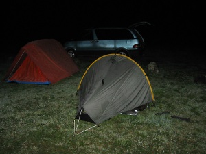
The tents are out - flexible budget travel


Phew. Not the way the placers meant this to be done… but sometimes you just have to do what you need to do!

Off to Greymouth for a few more caches, our long planned KFC meal (probably our last warm dinner for a few days), and on we pushed as night fell.

In the end we managed to get to the DOC camping ground a little north of Franz Josef, and we were set for a great start to day two.

Posted by: Pete | April 7, 2010

Wassup?

First a few weeks without any happenings, and then the 4.5 day, 2000 km Easter road trip with MrNoPrep!

Starting to recover from it now.

Just.

I’ll be posting about it in more detail as time and energy allows.

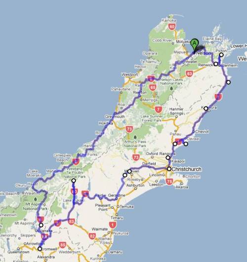
First, here is an image of the actual trip we took – Nelson to Cromwell to Nelson in four and a half days. During that time, we visited Greymouth, the Ross gold fields, both glaciers (Franz Josef and Fox), Haast, Lake Dunstan and Cromwell, Lindis Pass, Lake Tekapo, South East Canterbury, Rangiora, North Canterbury/Kaikoura Coast, Blenheim, Picton and finally back to Nelson!

2010 Easter Road Trip - not showing minor side trips

Lots of photos, lots of geocaches, and lots of fun times. More to follow.

For the trip:

1 FTF, 116 caches found, 6 DNFs.

Older Posts »

Categories